 |
Jim Douglas Mine--Holy Joe Peak Quadrangle southern Arizona | |
|
Jim Douglas Mine--Holy Joe Peak Quadrangle southern Arizona | |
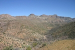
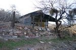
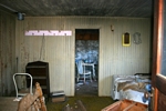
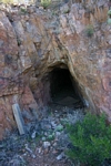
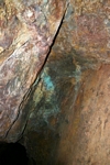
In my search for old mining equipment, I look for remote mines that are listed as past producers. I found one unnamed mine on the side of Mining Mountain west of Holy Joe Peak in southern Arizona that seemed to fit the bill. I had determined its status by plugging its latitude and longitude co-ordinates into a Arizona mine database that I have. I had also determined that its name was the Jim Douglas Mine. a copper and silver producer. The map did not show any roads into the mine, so I was hoping that any equipment that might have been packed into the area might still be there. The closest approach to the mine would have been up out of the Aravaipa Canyon to the west of the mine. Since that area was primarily private property, I thought that I would approach on foot by the way of Holy Joe Canyon from the southeast.
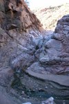
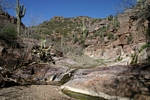
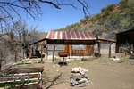
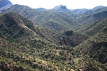
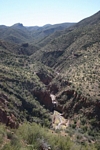
I was able to drive to the rim of Holy Joe Canyon from Highway 77 on the Zapata Wash Road. On foot, I dropped down to the bottom of Holy Joe Canyon. The canyon was quite scenic. There was water flowing. The only detriment was that there was an excessive amount of cattle "sign". In a couple of miles I came to an old homestead. Below the homestead, the canyon narrowed and there was some easy scrambling over several rock ledges. I did eventually reach an impassable pour-off in the canyon bottom. It was time to climb up the side of Mining Mountain. The climb was steep, but I eventually reached an old trail that led to the mine. It was disappointing to find a relatively good road coming from out of the Aravaipa Canyon to the mine. It looked like there had been some "clean-up" done by a bulldozer in the area. There was no evidence of any buildings or any equipment. All that remained was an ore chute and a mine opening. Oh well! It had been a good workout and Holy Joe Canyon had been scenic. There was little to do but to return to the truck. Distance hiked about 8 miles round trip.
 |
 |
 |
 |
 |
 |
 |
 |
 |
 |
| Trips |
| Home |