 |
California to New Mexico--A Backroads Route Across Arizona |
|
|
California to New Mexico--A Backroads Route Across Arizona |
|
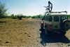
In April of 2000, I drove a route across the state of Arizona on unpaved backroads from Highway 78 in California to Highway 70 in New Mexico. This is a southern route across the desert areas of the state. It took me 5 long days and I covered 500+ miles with just about two miles total of driving on pavement. I had put the route together by driving and exploring each of the sections beforehand. I was not looking for the quickest route or the most difficult route, I was looking for "A" route. The vehicle that I used was a 1968 Toyota Land Cruiser with two gas tanks having a total capacity of 33 gallons. I was able to make the trip by refueling once near Toltec Arizona. My mountain bike accompanied me as my "spare" vehicle.
It is now 2007, I do not know if this route can still be duplicated with as little pavement driving as before. Crossing the Yuma Proving Ground by the way of the Trigo Wash may no longer be possible. The urban areas around Maricopa, Arizona City etc. may have more paved roads.
A detailed description of the route can be found here:
This is a very general description of the route:
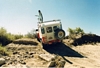
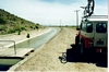
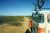
The route starts in California on a farm road off of Highway 78 south of Blythe (33* 23.37"N 114* 43.22"W). It is about a half mile to a farm bridge that crosses the Colorado River into Arizona. From that crossing, travel is a mixture of driving on levee roads, a good county road(Cibola Road), wash driving(Trigo Wash) and easy four wheeling through the Trigo Mountains of the Yuma Proving Ground to Highway 95 about 40 miles into Arizona. This was the driest and the most sparse of the desert areas that I crossed.
Click on Photos to Enlarge:
 Crossing the Colorado River |
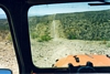
 Trigo Mountains Double Track |
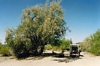
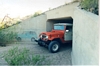
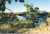
The route continues directly across US 95 on Blevens Pipeline Road as it crosses the northern end of the Kofa Wildlife Refuge. It would be about 130 miles until I saw pavement again near Gillespie Dam. I turned off of the pipeline road to head south through the refuge following the Wilbanks Road from Kofa Cabin to Hovatter Ruins and then out of the refuge on Hovatter Road. This was travel through very scenic desert country, that passed the Kofa Monument, Wilbanks Cabin, Hoodoo Cabin,and Hovatter Ruin with its circular driveway of saguaro cactus (link to Wilbanks Road page). Campsite #1 was at Hoodo Cabin for me. My routine on this trip was to essentially drive from shortly after dawn to just before dark. I had to stick with the program if I was going to get the job done in the time allotted which was the 5 days of my spring break.
 Kofa Scenery |
 Wilbanks Road |
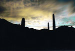
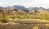
From the Refuge, I traveled eastward on Hovatter Road then turned south to the Raven Wash Road, crossing the Palomas Plain with its many Ironwood trees to the Arlington Clanton Road. The Eagletail Wilderness was to the North. The Clanton road led into a very good county road that allowed me to pickup the pace and I quickly passed many farm fields that dotted the Harquahala Plain. At a gas line road I turned southeastward to an old railroad siding at Crag, past an El Paso compressor station and then hit old Highway 80 just west of Gillespie Dam.
 Snack Break near Clanton Well |
 Eagle Tail Wilderness |
 Crossing the Harquahala Plain |
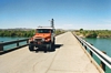
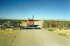
In order to cross the Gila River, it was necessary to drive on pavement about a 1/2 mile at Gillespie Dam. Immediately afterward, I jumped onto a canal road then continued eastward across Highway 85, the Little Rainbow Valley, and down along the east side of the North Maricopa Wilderness Area. From there I turned back west through an old Butterfield Stage Station and then south across Highway 238 to duck under a set of railroad tracks west of Shawmut to spend a very windy night #2 just north of the South Maricopa Wilderness.
 Canal Road |
 Crossing under RR tracks |
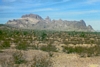
The third day was spent getting through the civilized areas around Maricopa, Stanfield, Arizona City, Eloy, and Coolidge by navigating powerline roads, dirt subdivision roads and farmroads. At Highway 84 near Peter's Corner, I was 270 miles from California, had crossed 7 paved roads and had driven a total of about .7 miles on pavement. My refueling point at Exit 208 on Interstate 10 was about 30 miles ahead. The gas gauge was really getting low. I wondered whether I was going to get to ride the bike. But we(the truck and I) made it with 3 gallons to spare. In 2000, the longest stretch of pavement driving was at Exit 208. It was about .9 miles. Crossing over 1-10, I traveled northeastward on more farm roads to cross Highway 87 and headed east for Picacho Reservoir. I crossed quite a few paved roads in this section but didn't have to drive down the length of any! From Picacho Reservoir, I crossed the CAP Canal, passed through the Picacho Mountains and took the Deepwell Ranch Road north to another gas line headed east. I crossed Highway 79 then passed to the north of the Black Mountain and camped for nite #3 near Camp Grant Wash just northwest of Oracle.
 Hidden Valley Powerline |
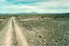
 Obscure Trail near Picacho Reservoir |
On day 4, I travel northeast to pick up another gas line road. This was the first real 4wd section of the route. From west of highway 77 to east of San Manuel, low-range was frequently needed. At Peppersauce Canyon, a good county road was encountered that took us up the San Pedro River Valley, past Redington, where I picked up the 3 Links(Wilcox) road. After navigating the northwestern side of Wilcox, I traveled up yet another gas line road northward along I-10. I continued on the gas line until I could cross the northern end of the Fisher Hills, Highway 191and the railroad tracks. I then made my way across the San Simon Valley with its Chihuahuan desert shrubbery to the Fan Road. Night time found me camped near dry Parks Lake.
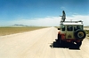
On day 5, I continued north towards Ash Peak where I picked up a gas line road eastward through a break in the Peloncillo Mountains. After clearing the mountains I traveled southward to an abandoned natural gas compressor station. From here on southward, there was some zigging and zagging to bypass washouts in the road headed for the railroad tracks. Once at the tracks it was possible to continue south until I hit the Lazy B Ranch Road where I turned east to Highway 70 about 20 miles north of Lordsburg, New Mexico(32* 35.97"N 108* 58.39"W).
 Gasline road near San Manuel |
 San Simon Valley |
 Artesian Well Rabbit Farm |
Gasline road east side of Peloncillos |
 New Mexico |
Four of the five days were very long in the saddle--8hrs,11hr,9hrs,12hrs, and 3hrs. 43 hours in total to go a little more than 500 miles. The average speed figured out to be about 12 mph. I think that I got a bit of the feeling that pioneer folks might have felt on their adventures. "Are we there yet?" I passed the time looking at the scenery and listening to talk radio. Without the radio, there would have been some rather monotonous times.
It took 58 gallons of gas. I made it with one refuel. With one of my newer trucks, I would have probably had to refill at least twice. With the two extended times of driving on pavement(.5m at Gillespie Dam + the .9m at Exit 208 + the crossing of the 22 paved roads that I crossed over enroute, I figure about 2 miles of paved road driving--that's less than 1% of the total). I figure that I could have connected the starting point and the finishing point by paved roads in about 8 hours or about a day of driving. So it was an interesting way to cross the state!
| Trips |
| Home |